PROTECTION OF WILDLIFE CORRIDORS- A MANDATE TODAY
GIS analysis of fragmentation of tiger corridors due to urban civilization
GIS analysis of fragmentation of tiger corridors due to urban civilization
 Shreyash Ramojwar
June, 2019
Shreyash Ramojwar
June, 2019
Historically, anthropogenic activities had adverse effects on nature. Tiger (Panthera Tigris), pre-eminent for its strength and ferocity; enthralls human attention by its majestic manner. Such a charismatic species plays a pivotal role for well-being of ecosystem. Being at the apex of food chain it maintains the population of hoofed animals, thereby maintaining the balance between the wild herbivorous animals and the vegetation they feed upon. Unfortunately, the aura of the tiger and the awe it inspires has caused their population decrease significantly over the century owing to relentless poaching for traditional medicines, folk remedies and status symbol amongst Asians. However, considering it as a major threat to their existence numerous conservation practices has prospered for their survival.
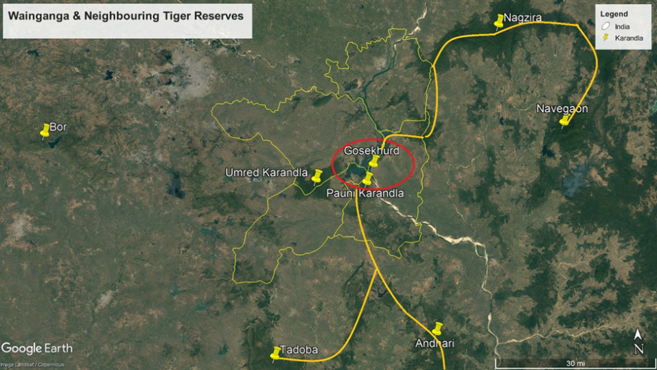
Our case study is mainly deals with the eastern part of Vidarbha Region in Maharashtra as it contains Tadoba Andhari National Project, Navegaon National Park, Umred and Pauni Karandhla Tiger Reserve, Pench National Park, Bor Wildlife Sanctuary, and several unprotected areas.These forest tracts and corridors shapes a network of habitats for wildlife and act as a medium to reduce negative effects of inbreeding and reduce genetic drift that may result due to isolated population.
Wainganga; one of the principle tributary of River Godavari passes through this region. The valley of Wainganga River is home to all the above mentioned wildlife habitats. Wainganga fosters unique geological landscapes as the typical basaltic rocks of 66 million old Deccan trap in Maharashtra comes in contact metamorphic crystalline rocks making its geology unique in the state. A lot of mining activities has been encouraged in this region mainly for manganese and coal which contributes for almost 29% of mineral outputs of the state.The valley of Wainganga is of utmost importance because it serves as lifeline for the forests it accommodates. However, its flow has been obstructed at various locations via construction of dams for facilitating irrigation. Vidarbha recently became infamous for large number of farmer suicide enforcing government to take forefront in building large dams. Consequently, Gosekhurd on Wainganga river publicized as Bhakra Nangal Of Vidarbha was developed by Water Resource Department which perhaps ultimately became one of the biggest scams of country for its major failure in providing irrigation facility and poor network of canals.
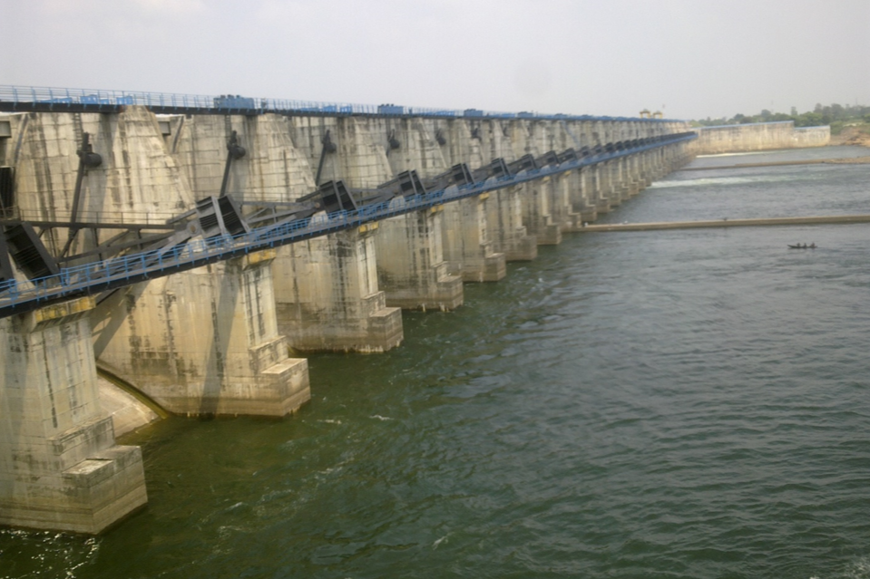
Gosekhurd is an earth fill dam which gives birth to Indira Sagar Reservoir. It is located in Pauni taluka of Bhandara and irrigates Nagpur, Bhandara and Chandrapur included in its command area. Construction of Gosekhurd has been done in way that it falls at the midway of tiger corridor which connects Tadoba National Park with Nagzira National Park via Umred and Pauni Karandhla Tiger Reserve.
Gosekhurd dam has stimulated a great land cover changes in water bodies and cultivated areas over its period of construction. GIS analysis was performed to study the fragmentation of tiger corridors by construction of dam and intense canal network. Supervised Classification of dam’s cpmmand area using minimum distance to mean classifier was done for estimating the amount of change over the period.
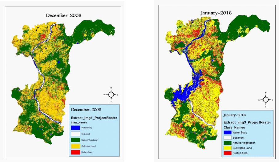
Five classes of waterbody, sediment, natural vegetation, cultivated land and built up area was identified. Classification results clearly stresses the increase of water body highlighted in blue colour, shown below.
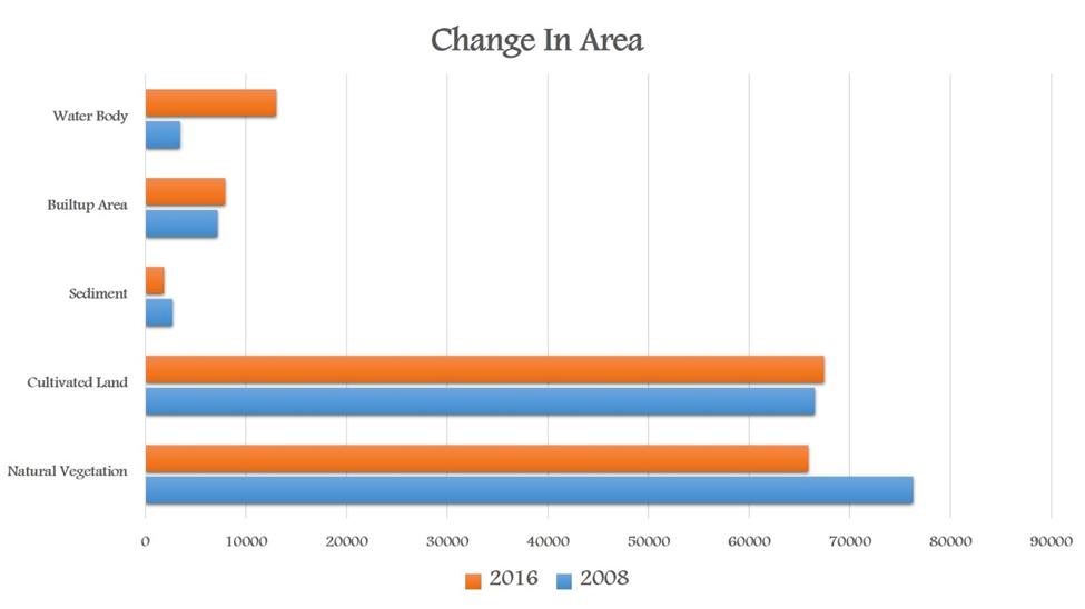
Analysis reveals that the amount of water body has increased over the period which can be attributed to the irrigation project. Consequently amount of cultivated areas has also increased but at the cost of fragmentation of corridors. Tadoba-Navegaon corridor is one of the efficient corridors of the country with potential candidates like Jaichand, Wagdoh, Maya, etc. A lot of incidents happened since then where tigers and other wild animals are found slipping into the canals while crossing through corridors.
“Wildlife corridors are link between two or more wildlife habitat and wildlife population. They aid to smoothen movement/migration of animals between habitats for resources such as food, water, shelter and breeding and ensures genetic exchange.”

One such incident happened in February 2018, when three and a half years old ‘Jaichand’ the dominant male species of Umred Karandhla Wildlife Sanctuary accidently slipped into the right bank canal of Gosekhurd while apparently chasing a wild boar. He was successfully rescued out of that watery grave with help of forest officials and few local residents. Jaichand is male offspring of ‘Jai’ who is reputed as the largest tiger of Asia. He derives his name from his parents ‘Jai and Chandi.’

This particular incident points about the lethality of such linear projects. Increasing anthropogenic pressures such as developmental activities, mining and construction of dams is leading to distribution and isolation of animal population and decrease in their abundance. Besides being criticized by the experts projects like Gosekhurd and other irrigation and mining projects are fragmenting animal corridors and government is expediting on diversion of water through dams and canals and other river linking projects. However, sustenance of habitat does not seem to feature in discussions.
Use of remote sensing and GIS will help in analyzing, manipulating and visualizing wildlife data for management of interventional projects. Habitats and their requirement, population and their linkage, historical and present population densities can be examined using GIS software ensuring natural resources and wildlife are least affected. Spatial analysis of currently affected areas and potential future spread can help us focusing our efforts to cope for the harm done. GIS and GPS will help to document and track the migration patterns of animals. GIS as a part of day-to-day operations can serve as most effective tool for conservation.
Shreyash is a student of Geoinformation and Remote Sensing. Being a student from technical background; his interests includes conservation and sustainable development. He works in the domains of watershed management and resource development activities in drought prone areas of Bhokardan.